படிமம்:Karta PG Woodlark isl.png
Jump to navigation
Jump to search
இந்த முன்னோட்டத்தின் அளவு: 280 × 187 படப்புள்ளிகள் . மற்ற பிரிதிறன்: 300 × 200 படப்புள்ளிகள் .
மூலக்கோப்பு (300 × 200 படவணுக்கள், கோப்பின் அளவு: 5 KB, MIME வகை: image/png)
சுருக்கம்
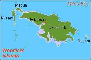
| விளக்கம் |
English: Map (rough) Woodlark islands, Papua New Guinea, own work composed from various mapreferences |
| நாள் | |
| மூலம் | சொந்த முயற்சி |
| ஆசிரியர் | Hobe / Holger Behr |
அனுமதி
| I, the copyright holder of this work, release this work into the public domain. This applies worldwide. சில நாடுகளில் இது சாத்தியமில்லாது போகலாம். அவ்வாறாயின் : I grant anyone the right to use this work for any purpose, without any conditions, unless such conditions are required by law. |
கோப்பின் வரலாறு
குறித்த நேரத்தில் இருந்த படிமத்தைப் பார்க்க அந்நேரத்தின் மீது சொடுக்கவும்.
| நாள்/நேரம் | நகம் அளவு சிறுபடம் | அளவுகள் | பயனர் | கருத்து | |
|---|---|---|---|---|---|
| தற்போதைய | 12:26, 30 செப்டெம்பர் 2007 | | 300 × 200 (5 KB) | wikimediacommons>Hobe | {{Information |Description=map woodlark islands, Papua New Guinea |Source=self-made, composed from various mapreferences |Date=2007-09-30 |Author= Hobe Category:Maps of Papua New Guinea }} |
கோப்பு பயன்பாடு
பின்வரும் பக்க இணைப்புகள் இப் படிமத்துக்கு இணைக்கபட்டுள்ளது(ளன):